UTM Coordinates
A Quick Introduction to UTM Coordinates
UTM coordinates are an option in nearly every outdoor recreation GPS receiver, and a common secondary grid on U.S. topographic maps. Most users leave their GPS on the default lat/lon setting and never explore UTM — but figuring it out is usually a meaningful upgrade for backcountry navigation. Two numbers — an easting and a northing, both in meters.
At the local level, a UTM coordinate is a position measurement consisting of an east-west position and a north-south position, both measured in meters.
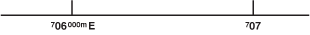
It might look something like this: 10S 706832m E 4344683m N. It's good practice to include the unit of measure ('m' for meters) and the direction of the measurement ('N' for North, 'E' for East). It's also common to see only the numbers themselves: 10S 706832 4344683.
By convention, the east-west measurement is always first. The east-west measurement is called the 'easting' and the north-south the 'northing.'
The 10S at the beginning is the UTM zone. Important at a global level, but for now, just ignore the zone.
These skills work in two directions: reading a coordinate from a feature on the map (you have a point, you want its coordinate) and plotting a coordinate onto the map (you have a coordinate, you want to find the point). Same tools, same techniques — the inputs and outputs swap.
What it Looks Like on a Map
Common large-scale maps used for hiking — large-scale meaning more detail per square inch, like 1:24,000 — will have a 1000m UTM grid printed on them. They will be squares 1000 meters on a side. (Don't confuse them with Public Land Survey System Sections, which are 1 mile square, often printed in red and usually numbered in their center.)
Where the UTM Grid lines meet the edge of the map, they will be numbered with their easting or northing value. The label could be either the full easting or northing in meters, or an abbreviated value omitting the rightmost 3 digits. In this example, the 707 is an abbreviation for 707000m E.
What it Looks Like on a GPS Receiver
A GPS receiver tells you the UTM coordinate of where you're standing. The most common reason to work in the plotting direction — turning a coordinate into a point on the paper map — is to take a GPS reading and figure out where on the map you actually are.
Almost every GPS receiver designed for outdoor recreation use, and many phone GPS apps, can be set up to display UTM coordinates. See GPS Setup for Map Coordinates.
It is common for a GPS receiver to display the zone and easting on one line and the northing on the line below.
If you want your GPS's UTM coordinates to match up with the ones on your map, you will need to get the map datum set up correctly in your GPS. See Map Datums.
Precision is a square on the ground
A UTM coordinate (and MGRS and USNG, which are built on UTM) always describes a square on the ground, with the size of the square set by the precision of the coordinate.
Useful intuition pumps:
- 1 meter square: about two doormats side by side.
- 10 meter square: about four parking places.
- 100 meter square: about two football fields side by side.
- 1,000 meter square: about a city block.
If you plot a coordinate and the resulting square doesn't match the kind of feature it's describing — someone says "I'm at the trailhead" but the precision is 1 km — there's a precision mismatch worth catching out loud.
Estimating UTM with 100m precision
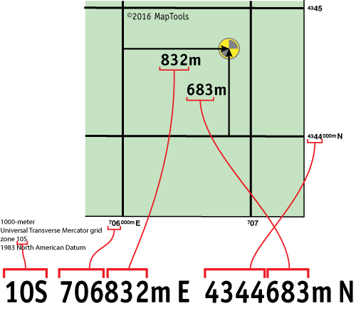
You don't always need a tool. The 1km UTM grid printed on a topo map is a built-in measuring tape — you just have to read it.
If you can see a feature on the map and the surrounding 1km grid, you can estimate its position by eye. Do it in two passes — easting first, then northing.
Easting (east-west position). Imagine dividing the west-to-east span of the 1km grid square into ten equal parts, each 100m wide. The part along the western edge is 000m; each part to the east is 100m more, so the middle of the square sits in the 400, 500, or 600m range and the part along the eastern edge is 900m.
Northing (north-south position). Same trick going south to north: the southern edge is 000m, each part north adds 100m, the middle is 400–600m, the northern edge is 900m.
Combine the two estimates with the printed grid labels for the full coordinate. If the easting label reads 706 and your easting estimate is 500m, the easting is 706500m E. The northing works the same way. The two estimates together place the feature in a 100m × 100m square — about the size of two football fields side by side.
The reported value has 100m precision, but eyeballing is less accurate than that — picking the wrong 100m strip on either axis puts you 100m or more from the true position. To get accuracy that matches the precision, you need a tool.
When writing or transmitting a 100m-precision coordinate, fill in the unmeasured digits with zeros — never round up. A point that is 146m east of the western grid line gets written as 706100m E, not 706200m E. The convention preserves a clear understanding of how precise the measurement actually is.
Using a grid-style tool to measure UTM with 100m precision
A grid-style tool is a transparent overlay carrying a printed grid that matches the map's 1km grid at the same scale. Lay the tool over the map so its grid lines align with the printed grid lines, with the relevant feature visible inside one square. Read the easting and northing off the marked subdivisions inside that square.
Grid-style tools give you 100m precision and 100m accuracy — the printed lines tell you exactly which 100m square the feature is in, with no eyeball guesswork between strips. They're fast, conceptually clear, and mechanize the eyeball technique with lines drawn for you instead of imagined.
MapTools sells a 1:24,000 pocket-sized grid tool in this family.
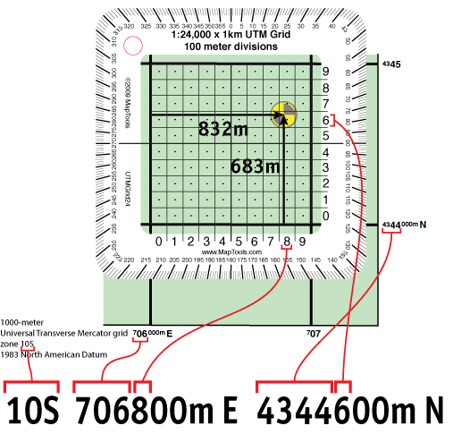
Using a slot-style tool for more precision
A slot-style tool trades the full grid overlay for a single open square (the "slot") with finely marked edges. The slot is shaped to fit a 1km grid square on the map. Slide the tool until the slot frames the relevant feature; the marked edges read out the easting and northing inside the slot.
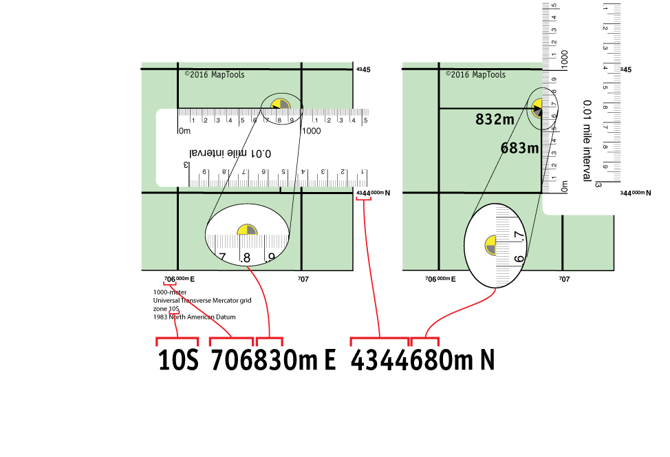
The slot's edges are marked at 10m intervals, so you can write a coordinate with 10m precision and achieve close to 10m accuracy — meaningfully sharper than a grid tool, which tops out at 100m on both. The bottom edge of the slot sits on the southern grid line and slides east-west to frame the feature, keeping the tool parallel to the grid by physical contact rather than by eye. The vertical edge spans exactly 1km at the tool's scale, so its top should reach the northern grid line; if it falls short or overshoots, the tool's scale doesn't match the map's (see Map Scale).
The slot tool is also the best of these tools for the plotting direction — turning a coordinate into a point on the map. From a coordinate like 10S 706830m E 4344680m N, the prefixes (706 easting, 4344 northing) name the 1km grid square. Lay the slot over that square with the bottom edge on the southern grid line. Mark the point at the easting and northing offsets — 830m east and 680m north — read directly off the slot's marked edges. Same marked edges, opposite operation.
MapTools sells a 1:24,000 pocket-sized slot tool in this family. John's "personal favorite tool style" — "all the accuracy you need" and "easy to keep parallel to the grid lines." For a step-by-step walkthrough with photos, see the MapTools slot tools tutorial.
When writing a 10m-precision coordinate, the same truncate-don't-round rule applies: a point at 146m east of the western grid line gets written as 706140m E, not 706150m E. The digits you write should reflect what you actually measured. At 1:24,000, 10m is the measurement floor — a 1m distance on the ground is too small to see on the map; for finer measurement, use a larger-scale map.
Using a map ruler to measure UTM coordinates
A map ruler is a longer, edge-marked ruler that doubles as both a UTM measuring tool (along the metric edges) and a Latitude and Longitude ruler (typically along the other edges).
Lay the ruler perpendicular to the western grid line at the relevant feature, with the zero mark on the western grid line. Read the meters east of that line directly off the ruler. Repeat with the ruler perpendicular to the southern grid line for the northing.
Map rulers carry the same 10m markings as the slot tool, so they reach the same precision ceiling and same potential accuracy at 1:24,000. Two trade-offs versus the slot:
- Pro: the ruler doubles as a lat/lon plotting tool and a straight edge for bearings work, so it's a multi-purpose tool to carry.
- Con: keeping the ruler parallel to the grid line is the user's job. Slot tools enforce orientation; rulers don't.
MapTools sells a 1:24,000 map ruler in this family.
UTM From the Global Perspective
The local easting and northing measured off a topo map are unique only inside one UTM zone. The Grid Zone Designation at the front of every coordinate (10S, 13T, 33N) is the zone label — it's what makes the full coordinate globally unique. UTM divides Earth's surface into 60 zones, each 6° of longitude wide, with latitude bands lettered C through X.
For most backcountry use the Grid Zone Designation is just a label you copy off your map and include when sharing the coordinate. For the deeper picture — false easting, the flat-grid-on-curved-sliver geometry, convergence between Grid North and True North, and the polar regions — see UTM Zones.
Other UTM-Based Coordinate Systems
UTM is the underlying numerical grid. Two systems package it in alphanumeric form for different communities — MGRS for military and NATO use, USNG for civilian U.S. emergency response. Both inherit the UTM geometry wholesale; the difference is notation, not measurement.
If you understand UTM, MGRS and USNG follow easily. If you don't, they look like magical pairs of numbers — and the abbreviated forms (6-digit, 8-digit) quietly invite digit-slip errors you have no way to catch.
MGRS
MGRS (Military Grid Reference System) is the U.S. military and NATO packaging, formalized in 1949 for artillery and inter-service coordination. The same physical point that UTM writes as 10S 706832m E 4344683m N is written in MGRS as:
10S GJ 06832 44683
The two-letter GJ is the 100,000-meter Square ID — a unique label for the 100km square inside zone 10S that contains the point. With the square identified, the easting and northing only need to express the position within that square, so they shrink from 6+7 digits to 5+5.
MGRS abbreviates further by dropping trailing digits: 0683 4468 is 10m precision, 068 446 is 100m, down to 0 4 at 10km. The abbreviation made sense in the late-1940s era of Morse-code and scratchy-voice radio — keeping a coordinate short was a real operational constraint. Today it isn't, but the abbreviated forms remain in heavy use. They carry a real failure mode: slipping a digit one position left or right produces a well-formed coordinate at a totally different location, with no error indicator. UTM's fixed 6+7 digit count doesn't have this hazard. Use the full form.
MGRS is the lingua franca for military, allied military, and many SAR teams. It also persists in civilian recreational use, especially among veterans.
By default MGRS is referenced to WGS 84; older NAD 27 MGRS coordinates carry a 10-letter shift in the 100km square ID. See MGRS Coordinates for the full treatment, including datum handling.
USNG
USNG (the U.S. National Grid) is the civilian U.S. equivalent of MGRS. Same five-component structure, same map grid, same precision-by-digit-count convention — and the same digit-slip hazard in the abbreviated forms:
10S GJ 06832 44683
The two systems are nearly identical at WGS 84/NAD 83 precision. Where they diverge is in handling NAD 27 (USNG requires the datum to be specified explicitly; MGRS shifts a letter) and in geographic scope (USNG is defined only for the U.S. and its territories).
USNG is what FEMA uses, what civilian SAR teams trained under FGDC standards use, and what some U.S. national parks have begun overprinting on their maps.
See USNG Coordinates for the full treatment.
Other Metric Grid-Based Coordinate Systems
UTM is one of several metric-grid coordinate systems that work the same way in principle — pick a projection, lay a meter-based square grid over it, label the lines. Many countries publish their own — the British National Grid, the Irish Transverse Mercator, the Lambert Conformal Conic-based systems used in parts of continental Europe, and others.
Two things to know:
- They are not UTM, even though they look similar at first glance — printed grid lines spaced in kilometers, easting and northing values measured in meters from a regional reference. The underlying projection is different, so a UTM-trained reader can't assume the numbers mean the same thing.
- At the plotting and reading level, they function similarly to UTM. The skills you learned here transfer: identify the grid square, measure the easting and northing within it, combine with the grid label. Outside the U.S., these systems are often more useful than UTM for in-country navigation, but UTM is still readable on most modern topo maps as a secondary grid.
For interoperability work (international coordination, multi-agency response), UTM and lat/lon are the universal lingua franca everyone agrees on. Other national grids are best handled by converting to UTM or lat/lon at the boundary of the conversation.
Choosing a coordinate system
For guidance on when to use UTM vs. lat/lon vs. MGRS vs. USNG, see Selecting a Coordinate System.
Further reading on maptools.com
- UTM Quick Guide — tutorial walkthrough of reading and writing UTM
- UTM on USGS Maps — how UTM appears on USGS 7.5' topographic maps
- Grid Zone Details — the UTM zone grid and what each piece means