MGRS Coordinates
What MGRS is
MGRS (Military Grid Reference System) is the alphanumeric packaging that the U.S. military and NATO use for the same underlying grid as UTM. A complete MGRS coordinate looks like:
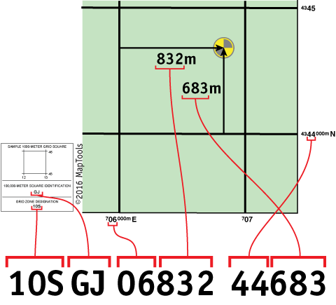
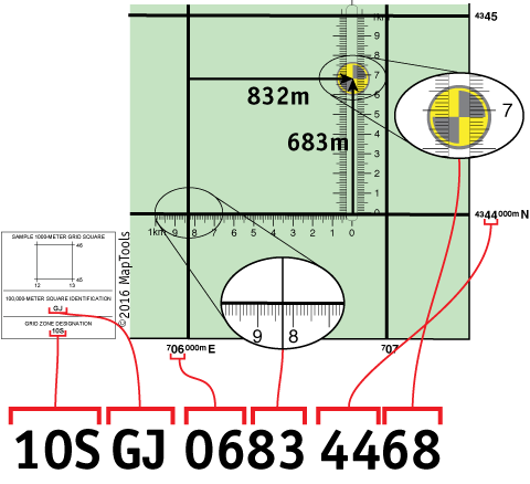
10S GJ 06832 44683
Five parts:
10S— Grid Zone Designation. The UTM zone number (1–60) and the latitude band letter. Necessary to make the coordinate unique over the entire globe.GJ— 100,000-meter Square ID. A two-letter code identifying a unique 100km square within the grid zone.06832— the Easting: east-west position within the 100km square, in meters.44683— the Northing: north-south position within the 100km square, in meters.
The same map grid lines are used for both MGRS and USNG; the difference is in how the position is written.
Precision is the number of digits
MGRS coordinates carry their precision in the digit count. Truncating digits is lowering precision; you don't add digits to gain precision.
| Form | Precision | Example |
|---|---|---|
10S GJ 06832 44683 |
1 m | full |
10S GJ 0683 4468 |
10 m | drop trailing digit |
10S GJ 068 446 |
100 m | drop two |
10S GJ 06 44 |
1 km | drop three |
10S GJ 0 4 |
10 km | drop four |
10S GJ |
100 km | square only |
When using less precise representation, it is important to truncate rather than round the Easting and Northing values. The Easting and Northing always refer to the southwest corner of the grid square.
Adding digits you don't actually have ("digits we don't have") is dishonest in SAR or military-coordination contexts, where the receiver assumes the precision is real and may make decisions accordingly.
Reading the easting and northing on a map
For the easting:
- The first two digits come from the large type on the label of the grid line to the west of the position.
- The last three digits are the distance in meters measured east from that western grid line.
The northing follows the same logic against the southern grid line.
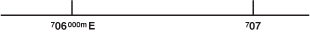
The label 706 is shorthand for 706000m E ("seven hundred and six thousand meters East") — the small superscript digits on the label tell you the full value, while the large type is what you read off when writing the easting.
A 1:24,000 USGS topo map prints UTM grid lines spaced every kilometer (every 1000 meters). The 1:24,000 Pocket-Sized Slot Tool (UTMSlot24) ruler measures the meters within a 1km square; combined with the gridline labels, it produces an MGRS coordinate to 10-meter precision.
Writing and saying it
The MGRS standard says, for machine-to-machine communication, an MGRS string should have no intermediate spaces or punctuation marks and all letters capitalized.
For human communication, do the opposite:
I would encourage you to use spaces when writing MGRS coordinate strings, and to pause briefly between logical parts when communicating MGRS coordinate strings verbally.
"One zero sierra · golf juliet · zero six eight three two · four four six eight three" is harder to mishear than the same string read as a continuous run of characters.
Datum
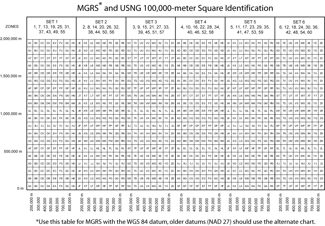
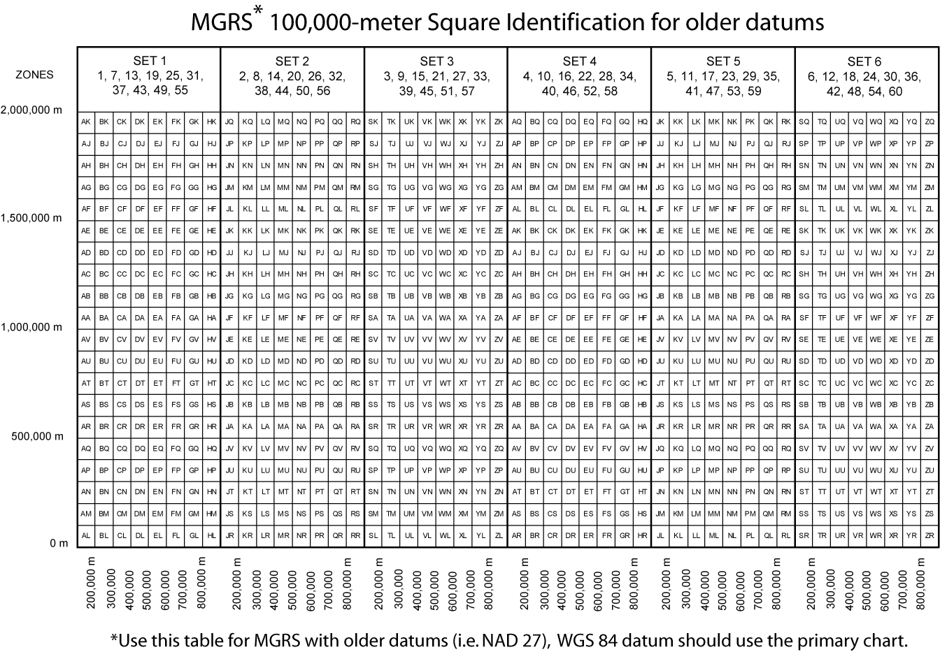
The MGRS standard has no formal way to specify the datum in the coordinate string itself. By convention, MGRS defaults to WGS 84.
The trap: MGRS coordinates from older maps may be referenced to NAD 27, in which case the second letter of the 100km square ID shifts by ten letters (excluding I and O) compared to the WGS 84 form. The same physical point can be written as:
- WGS 84 MGRS:
10S GJ 06832 44683 - NAD 27 MGRS:
10S GU 0706832 4344683
If you encounter MGRS that looks unfamiliar against a known location, suspect a datum-shift letter. See Map Datums and USNG Coordinates for the parallel handling in USNG (which doesn't shift letters but requires datum to be specified explicitly).
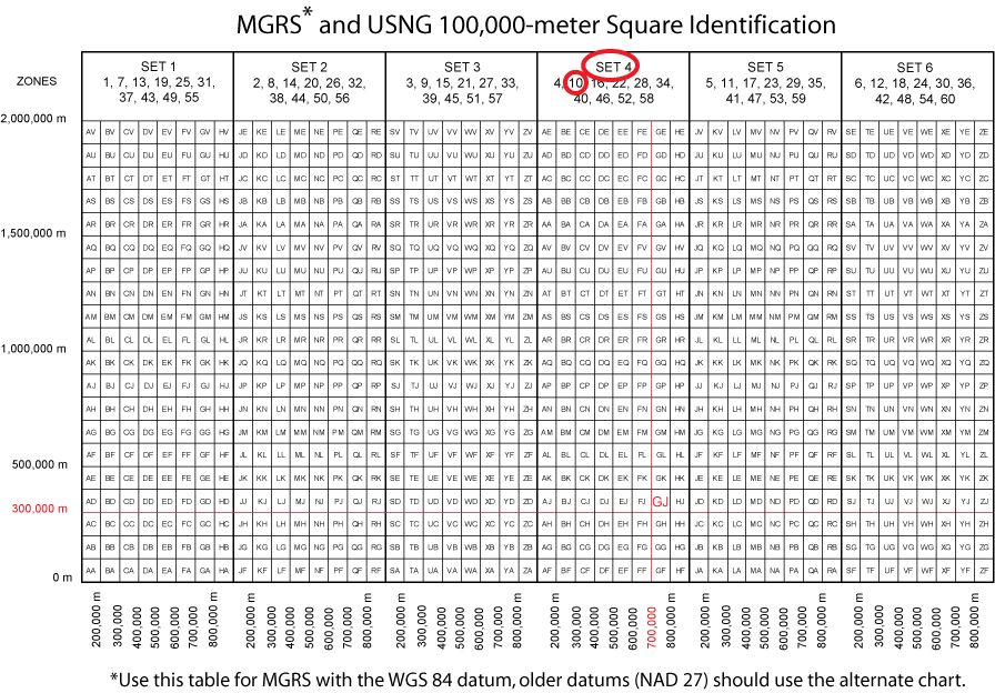
Downloadable NAD 27 / WGS 84 letter-pair charts. MapTools maintains two reference charts of the 100km square identifiers — one for WGS 84 (the primary chart, used on the maptools.com 100km Square Identifiers tutorial) and a second for older datums (NAD 27) that incorporates the second-letter shift. Print-sized 2× versions are linked from that page:
- WGS 84 chart: 100kmGridIDChart2x.png
- NAD 27 chart: 100kmGridIDChartAlt2x.png
Converting MGRS to UTM (and back)
MGRS and UTM are the same physical grid — different notations for the same point. Conversion is mostly mechanical: you trade the two-letter 100,000-meter Square ID for the leading digits of the UTM easting and northing (and vice versa).
MGRS → UTM. The two-letter square ID tells you which 100km × 100km block of the zone you're in. Each letter pair encodes a specific offset from the zone's reference point:
- The first letter identifies a column running east-west (in 100km steps from the zone's central meridian).
- The second letter identifies a row running north-south (in 100km steps from the equator, cycling every 2,000km because letters repeat).
Once you know the column and row offsets, you prepend them to the 5-digit easting and northing to reconstruct the full UTM coordinate:
- MGRS:
10S GJ 06832 44683 - The pair
GJin zone 10S resolves to easting offset7(hundreds of km) and northing offset43(hundreds of km). - UTM:
10S 706832 4344683— the7and43are the digits the pair encoded.
The encoding isn't arithmetic — it's a lookup table that depends on both the letter pair and the grid zone. For the full table and worked examples, see the MapTools 100km Square Identifiers tutorial, or just use the Coordinate Converter tool, which performs the lookup automatically.
UTM → MGRS. Drop the leading digits of the easting (typically 1) and northing (typically 2) and replace them with the matching letter pair from the same lookup table. The remaining 5 digits of easting and 5 digits of northing become the meters-within-the-square portion of the MGRS coordinate.
For more than a handful of conversions, don't do this by hand — the lookup table is non-obvious and slipping a letter pair produces a kilometer-scale error with no visual clue. Use the Coordinate Converter.
When to use MGRS vs. UTM vs. USNG
All three are the same grid; the question is which packaging to use:
- UTM — raw numerical form. Easting and northing in full meters from a zone reference. Best for survey work, GIS handoff, and any context where the explicit numerical values matter.
- MGRS — alphanumeric form with the 100km square prefix. Best for military, allied military, and SAR operations where the standard is in use. The 100km letter pair acts as a transmission-error sanity check.
- USNG — civilian U.S. equivalent of MGRS, used by FEMA and U.S. emergency-response agencies. Effectively identical to MGRS at WGS 84/NAD 83 precision.
Per the MapTools coordinate-system guidance: pick the system your peers are using, then worry about ergonomics. Mismatched systems between teammates are how coordinates get mistransmitted.
Common errors
It is easy to make a mistake using truncated position formats. Slipping a digit left or right results in a very different position. Worse, there is no visual clue that an error has been made until the coordinate is plotted.
The chief causes of student error:
- Mistaking the latitude band letter (one letter, e.g.
S) for part of the 100km square ID (two letters that follow). Worth saying out loud once. - Slipping a digit between easting and northing — the coordinate looks plausible but lands kilometers off.
- Truncating inconsistently. Pick a precision and write all your coordinates at it for a session.
Choosing a coordinate system
For guidance on when to use MGRS vs. lat/lon vs. UTM vs. USNG, see Selecting a Coordinate System.
Further reading on maptools.com
- MGRS Quick Guide — tutorial walkthrough of reading and writing MGRS
- MGRS vs USNG Differences — how MGRS and USNG diverge on datum handling
- 100km Square Identifiers — what the two-letter square ID means