Map Datums
Datum vs. coordinate system
These two ideas get conflated constantly, and they're not the same thing:
- A datum is the underlying Earth-model — the ellipsoid plus the reference points used to measure positions on Earth's surface. It answers "which Earth-model am I measuring against?" (NAD 27, NAD 83, WGS 84, etc.)
- A coordinate system is the notation used to write a position down — lat/lon, UTM, MGRS, USNG. It answers "how am I writing the position?"
The same physical point can be expressed in any coordinate system, and against any datum. Both choices matter: changing the coordinate system reformats the numbers; changing the datum moves the reference frame underneath the point, so the numbers come out slightly different even in the same notation.
For a more visual introduction, see the MapTools map datum tutorial.
What a datum is
Survey a small patch of land and you can treat the ground as flat — the math works. Survey a county, a state, a continent, and Earth's curvature starts to matter: distances and angles measured on a curved surface don't add up the way they would on a flat one. To work at that scale, the surveyor needs a mathematical model of the curved surface.
The model is an ellipsoid — a slightly flattened sphere, wider at the equator than pole-to-pole because the spinning Earth bulges. (Some GPS receivers and references call this a spheroid; same thing.) The ellipsoid, plus a network of carefully-measured surveyed reference points with their established coordinates, make up a datum.
Before satellites, no surveying party could measure across an ocean. So the practical answer was a separate datum for each region — its ellipsoid chosen as a best fit for that part of the world. Examples:
- NAD 27 — best fit for North America, anchored at Meades Ranch, Kansas.
- European Datum 1950 (ED50) — best fit for Europe, established for post-war mapping.
- Old Hawaiian Datum — best fit for the Hawaiian Islands, anchored on Oahu.
- Indian Datum — best fit for the Indian subcontinent, anchored at Kalianpur in central India.
Once we could measure the Earth from space, none of those constraints applied. A single ellipsoid could be defined as a best fit for the entire planet, with the reference frame anchored to the Earth's center of mass instead of to a single ground station. That's WGS 84 — and it's what every GPS satellite emits coordinates against.
A coordinate doesn't float in space — it's measured against the datum's reference points, on the datum's ellipsoid. Change the datum and the measurement framework changes underneath the point, so the same physical spot is assigned slightly different coordinate values — read out as lat/lon or as UTM easting/northing depending on the format. The coordinate changes even though the ground doesn't.
The datum is an important component of a coordinate. A coordinate with an unknown datum is an approximate location at best.
That said, in practice most coordinates get passed around without an explicit datum label. The datum is usually carried as context (the map's stated datum, the team's standing convention, the GPS's current setting) rather than written next to every number. That's a workable shortcut as long as the context is unambiguous; it stops being workable the moment a coordinate crosses from one context to another without the datum coming along with it.
Our understanding of Earth's shape keeps improving, and the tools we use to measure it keep getting sharper. WGS 84 won't be the last datum.
The three datums a U.S. user encounters
- NAD 27 CONUS — North American Datum of 1927. Common on older USGS topographic maps. Terrestrial-based: established from a triangulation station in Meades Ranch, Kansas, before satellite surveying existed.
- NAD 83 — North American Datum of 1983. Used on most newer USGS maps. Adopted as a world standard before WGS 84 superseded it.
- WGS 84 — World Geodetic System of 1984. The default datum used by GPS. Space-based: standardized on the center of the Earth, which makes it a good fit for the entire surface of the planet rather than for any particular continent.
How big are the offsets?
The numbers worth keeping in mind:
- NAD 83 vs. WGS 84: typically only a meter or two difference. Negligible for navigation.
- NAD 27 vs. WGS 84: can be as much as 200 meters in the continental U.S., varying by region — enough to put you on the wrong side of a ridge.
An incorrect datum can put you hundreds of meters from your actual position.
This is the catch that produces "the GPS says I'm here but the map says I'm there" confusion. The map and the GPS are both right within their own datum; they just disagree about what the numbers refer to.
How to identify your map's datum
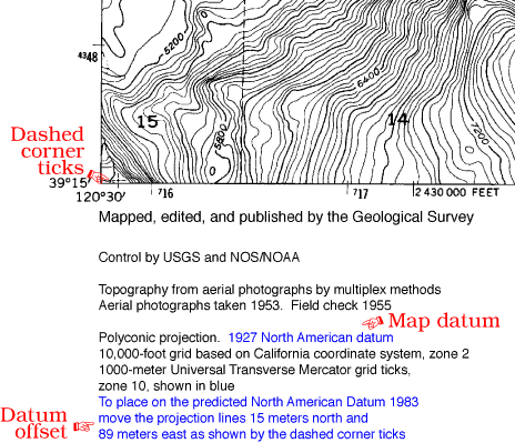
On a USGS topographic map, the datum information is in the fine print at the bottom-left of the collar. Check it before you leave the trailhead; check it as part of getting any new map onto the table.
- Older USGS maps are almost always NAD 27.
- Newer USGS maps may be NAD 83.
- Transitional maps sometimes include explicit conversion instructions or a dashed cross in the SW and NE corners of the map giving a visual indication of the offset between the two datums.
When the datum isn't stated, the safest default depends on the map's vintage and origin:
- A modern digital map (anything you printed yourself from a recent source, most third-party hiking maps, marine charts) is overwhelmingly likely to be WGS 84. The civilian world has converged on it.
- An older USGS paper topo with no stated datum is almost certainly NAD 27. The default predates the modern convention.
- A map with no printed datum reference and no identifiable vintage or source should be treated as approximate-only until you've verified the datum against a known feature.
Don't guess from format alone — coordinates printed on a map look identical in NAD 27 and WGS 84; the difference is only in which Earth-model the numbers refer to.
Setting your GPS to match
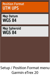
Most GPS receivers designed for land navigation let you change the map datum from the Setup menu. The rule is simple:
Always set your GPS unit's datum to match the datum of the map you are using.
A practical note about what the GPS shows on the same setup screen: alongside Map Datum you'll usually see a Map Spheroid field. You don't need to set the spheroid separately — it's the ellipsoid component of the datum, and it changes automatically when you change the datum. Selecting NAD 27 sets the spheroid to Clarke 1866; selecting WGS 84 sets it to WGS 84. Treat the spheroid field as informational and ignore it unless you have a specific reason to override.
See GPS Setup for Map Coordinates for the full configuration walkthrough — position format, datum, north reference, units, and data fields.
For mixed-mission work where ground, aviation, and maritime users are coordinating, the tolerance varies. Pilots might tolerate "several hundred meters" of error; a ship in rough seas might not. If precision matters, the datums must match — or coordinates must be converted explicitly before they leave one team for another.
Converting between datums or formats using a waypoint
A useful field trick when someone hands you a coordinate in a datum or format different from the one you're set up for: use a waypoint as the converter.
The procedure on most receivers:
- Note your current Position Format and Map Datum settings — you'll restore them at the end.
- Change Position Format and Map Datum on the GPS to match the coordinate as written. (Example: someone gives you
N 37° 25.423′ W 122° 12.541′ WGS 84and you're normally set up for UTM/NAD 27. Switch the GPS temporarily to lat/lon decimal-minutes and WGS 84.) - Create a new waypoint and edit its coordinate fields to the values you were given. Save it.
- Switch Position Format and Map Datum back to your usual settings.
- Open the waypoint. It now displays the same physical point in your preferred format and datum.
This works because the GPS stores the waypoint internally as a fixed position on the Earth and re-renders it through whatever format/datum is currently selected. The same trick converts MGRS to UTM, NAD 27 lat/lon to WGS 84 UTM, and any other pairing the GPS supports — without needing a computer or an online tool.
For converting more than a handful of coordinates at a time, switch to a computer-based or web-based conversion tool — the waypoint method is meant for one-off field conversions. Two starting points:
- The MapTools Coordinate Converter — common conversions in a browser.
- NOAA's NGS Coordinate Conversion and Transformation Tool (NCAT) — authoritative for U.S. datum transformations. The URL has shifted over time; search "NGS NCAT" if the link is dead.
Datums and MGRS / USNG
A subtle point that catches users of older maps — the two systems handle datums differently.
MGRS was adopted in 1949 and predates WGS 84 by 35 years; it has been used historically with whatever regional datum the local maps were drawn on. The modern convention treats WGS 84/NAD 83 as the implicit default, with NAD 27 handled by an explicit letter-shift convention.
- MGRS can be used with any datum. There's no formal way to write the datum into the coordinate, but it still matters and should still be specified in any context where the receiver might not be configured for the matching datum. When the datum is NAD 27, MGRS applies a letter shift to disambiguate: the second letter of the 100,000-meter square identifier is advanced by 10 positions in the alphabet (skipping I and O, which MGRS never uses). The rule is the same in every zone. Examples: a second letter of
Ashifts toL;Fshifts toR;Jshifts toU. - USNG only supports NAD 83/WGS 84 or NAD 27. The default is NAD 83/WGS 84; if NAD 27 is used, the datum must be written explicitly alongside the coordinate, e.g.
10S EH 597 822 (NAD 27). USNG does not shift letters for NAD 27.
A worked example for the same physical point under NAD 27:
- MGRS:
10S GU 0706832 4344683(the second letter is shifted fromJtoU) - USNG:
10S GJ 0706832 4344683 (NAD 27)(no shift; datum written explicitly)
If you encounter MGRS coordinates from old maps with a letter pair that doesn't match what your GPS computes for the same physical point, suspect the NAD 27 shift first.
A practical note on format: the abbreviated MGRS short forms (597 822, 5974 8221) made sense when coordinates were sent by Morse code or over a scratchy field radio — keeping the string short was a real operational constraint. Today, modern data links carry the full coordinate easily, and the full easting/northing carries enough redundant information to detect a slipped digit. Default to reporting the full easting and northing as read from the GPS, and match whatever convention the people you're working with have agreed on.
Other datums
A typical handheld GPS receiver lists more than 100 datums as options — the long tail of regional datums going back centuries.
If you're traveling internationally, the safe assumption is that local datums can produce kilometer-scale offsets from WGS 84 — far worse than the NAD 27/WGS 84 case in the U.S. Set the GPS to match the map's datum. The simpler alternative: set the GPS to WGS 84 and carry only WGS 84-referenced maps.