MapTools Logo
  • Home
  • About Us
    • About Us
    • Contact Us
    • News
    • Privacy Policy
  • Products
    • UTM, MGRS, and USNG Tools
    • Latitude Longitude Tools
    • Ruler Sets for Benchmark Atlases
    • Ruler Sets for DeLorme Atlases
    • Custom Map Rulers for any Scale
    • Stock Tools Listed By Scale
    • Instructional and Reference
    • Other Useful Tools
    • All Products
    • Custom Made Tools
    • Maps from MyTopo
  • Tutorials
    • Choosing a Geographic Coordinate System
    • UTM/MGRS Coordinates
    • USNG Coordinates
    • Lat/Lon Coordinates
    • North References for Navigating with Map, Compass and GPS
    • Using your Compass
    • Plotting a bearing onto your map
    • Video Tutorials
    • FAQ
  • Resources
    • Map Scale Calculator
    • Resources for Navigation Instructors
    • Useful Links
    • Dealer List
    • Government Purchasing
    • Wholesale Purchasing
    • Free PDF Tools
  • Contact
  • Search
  • Your shopping cart

Printed Maps from MapTools

MapTools has partnered with MyTopo.com to provide you with custom printed topographic maps and aerial photography.


Start Building Your Map

Step 1 of 5: Find an area


Step 2


Step 2 of 5: Build your map

Step 2 Scale

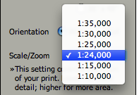
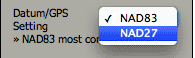
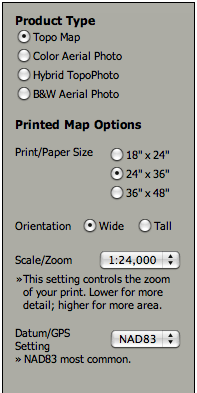
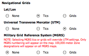
Step 3 of 5: Choose Your Product Type

  • Waterproof "Outdoor" Map -- Folded or Rolled
  • Glossy "Poster" Map
  • Laminated Map

Step 4 of 5: Customize Your Map

Step 4 Grids or Tics

Grids

Step 5 of 5: Review Your Map

©Copyright 2023 MapTools All Rights Reserved
For more information please contact us