Quantity Pricing for Custom Rulers
July 2026
Custom rulers now come with automatic quantity discounts. A single ruler is still $8.95, but the per-ruler price starts dropping with your second ruler and tapers all the way down to $4.50 each on orders of 50 or more.
The discount counts every custom ruler in your order, not just copies of one design — mix five different scales, or five copies of the same design, and both count toward the same price break. The simple ruler designer and the advanced designer now show the full price table as you design, along with how many more rulers reach the next break. And because the discount is order-wide, adding rulers can lower the price of rulers already in your cart.
Outfitting a team or a class? Browse the ready-made community tools and collections and add a whole matched set to your cart in one click.
Interactive UTM Tutorial
July 2026
Working with map coordinates is easier to show than to tell. Our new interactive UTM tutorial walks you through plotting and reading UTM coordinates step by step, animated on a real topographic map. Pick a problem and watch each move happen — finding the grid square, placing the tool, reading the scales — with every step explained on screen, at your own pace.
The tutorial demonstrates both styles of coordinate tool we make: the UTM grid overlay and the slot-style corner scale. It speaks MGRS and USNG as well as UTM, and it can even draw the NAD27 and WGS84 map datums side by side, so you can see exactly why the datum printed on your map matters.
Start with plotting a coordinate with the grid overlay, or try reading a coordinate with the corner scale.
Ask the MapTools Knowledge Base
June 2026
Have a question about coordinates, declination, map scale, or how to use one of our tools? Our new Knowledge Base lets you ask in plain English and get a straight answer drawn from years of MapTools instruction. Type a question the way you'd ask a person — “how do I plot a UTM coordinate?” or “what's the difference between true north and magnetic north?” — and you'll get a clear, focused reply. It's free to use, no account required. Give the Knowledge Base a try.
The Instructor's Corner
June 2026
If you teach land navigation, the new Instructor's Corner is for you. It gathers core topics, exercises, teaching aids, and articles from the MapTools knowledge base into one place built for instructors — including notes on the misconceptions students stumble over and how to teach around them. Visit the Instructor's Corner to take a look.
Coordinate Converter Tool Now Available
May 2026
If you work with maps, GPS devices, or navigation tools, you probably work with coordinates. The challenge is that coordinates come in many different formats: decimal degrees, degrees and decimal minutes, degrees minutes seconds, UTM, MGRS, and USNG. Each system has its strengths, and sometimes you need to convert from one format to another. That's where our new coordinate converter tool comes in.
The converter is fast and real-time. As you type or paste a coordinate in any supported format, it automatically detects what you've entered and displays the conversion to five other formats. It supports four datums: WGS84, NAD83, NAD27, and auto-detection. Copy any of the converted formats to your clipboard with a single click. Whether you're plotting points on a topographic map, entering coordinates into a GPS unit, reading a military grid reference, or working with survey data, the converter makes it easy to move between the coordinate systems your various tools require.
The tool accepts coordinates in six different input formats: Decimal Degrees (DD), Degrees Decimal Minutes (DMM), Degrees Minutes Seconds (DMS), UTM, Military Grid Reference System (MGRS), and U.S. National Grid (USNG). No matter how your coordinates are formatted, the converter understands them. Try the coordinate converter today and see how much time it saves.
A New MapTools Website
April 2026
The site you're reading this on is brand new. We've replaced the PHP storefront that served maptools.com for many years. The old code had grown crusty enough that adding the features we wanted was getting harder than starting fresh.
The headline feature is our new advanced custom ruler designer. The 2018 simple ruler designer let you pick one scale per edge from a fixed list. The new designer lets you put 17 different measurement scales onto your ruler, combine multiple scales on a single ruler, and arrange them however you need. If you've ever wanted a 1:31,680 ruler with statute miles along one edge and decimal-minute latitude along another, you can now build that yourself.
The other big addition is customer accounts. With an account you can:
- See your complete order history
- Save and revisit the custom tools you've designed in your design library
- Share custom tool designs with teammates, or organize them into collections
- Save shipping addresses and preferences so checkout is faster next time
None of this is required — you can still place an order as a guest, same as before. But if you're a frequent customer, designing tools for a team, or just want to reorder a custom design six months from now without redoing the work, the account is here for you.
First Price Update in 8 Years, and Changes to International Shipping
February 2026
We held our prices steady for 8 years. That's been a quiet point of pride around here. But paper, ink, postage, and pretty much everything else costs more than it did in 2018, and so this month we adjusted prices for the first time since then. The increases are modest and bring us back into line with what it actually costs to make and ship our tools.
At the same time, we've changed how we handle international shipping. The short version: we're no longer shipping internationally directly through the shopping cart, except in rare cases. The longer version is on our international orders page — it's a story of postal-service rule changes, lost shipments, surprise duty bills from FedEx and UPS, and Amazon fulfillment hurdles that are too tall for a two-person company to clear.
If you're an international customer who'd still like to get tools from us, please reach out. We can usually find a way to get a small order to you, but the terms are different now and we want to talk through them up front so there are no surprises.
Ten Years with the Rebelle Rally
October 2025
This year was the 10th edition of the Rebelle Rally, and we've been there for every one of them. The Rebelle is a women's off-road navigation rally — no GPS, no internet, just a map, a compass, paper coordinates, and a real off-road vehicle headed across the desert. It's the kind of event our tools were made for, and it's been a privilege to outfit teams running it since the very first year in 2016.
The Rebelle is a lat/lon-only event, so what competitors need from us is map rulers with latitude and longitude scales matched to the maps the rally hands out, built to hold up to dust and sweat and to work fast under time pressure. A lot of what we've built over the past decade — and a lot of what we're working on next — has been shaped by what we've learned from the Rebelle and from the teams that compete in it.
We have some new rally-specific tools in the works for the years ahead. More on those when they're ready.
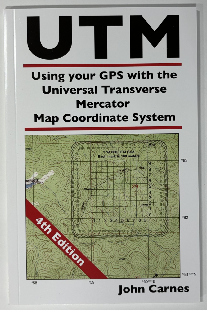
4th Edition of the UTM Guide
2024
We've released the 4th edition of "Using your GPS with the UTM Map Coordinate System". The 3rd edition was 50 pages; the 4th is 89. The new material includes:
- A chapter on finding maps with UTM coordinate grids — where to look and what to expect
- A chapter on using GPS waypoints — entering them, recording them, and getting them between your map and your device
- A chapter on how to use a map without a coordinate grid — because not every useful map comes with one
- And, finally, an index — three editions in, this is overdue and I know it
If you've worked through earlier editions, the 4th edition isn't a rewrite of what you already have — it's mostly additions and clarifications. If you're new to UTM, this is the edition I'd start with.
UV Inkjet Printer and Laser Cutter
2022
In 2021 we added two pieces of equipment that have changed what we can make: a laser cutter and a UV inkjet printer. Together they let us print and cut tools in-house, in small runs, at a quality we couldn't get any other way. Before this, every new tool design needed a minimum order of a few thousand units from a commercial print shop. Now we can make a hundred — or one — of something and see how it does.
The new equipment opened the door to a wave of new tool designs, including:
- RoundGTAQuads
- UTMGrid12 — a 1:12,000 scale grid overlay
- A 1:31,680 grid tool
- PocketSlotsQuads
It also gave us a family of large classroom training aids — oversized "-TA" versions of our regular tools that an instructor can hold up in front of a class to demonstrate how the small student version works. The current lineup:
- Compass-TA — large compass
- MapRuler-TA — large map ruler
- CornerRuler-TA — large corner ruler
- MiniCorner-TA — large mini corner
- UTMGrid-TA — large UTM grid overlay
- UTMSlot-TA — large UTM slot tool
And it let us bring a number of low-volume products in-house — products that previously had to be retired between large reorders. These now get made as we need them:
It also means we can take on one-off custom tool jobs that wouldn't have been practical before. If you've got an unusual map, an unusual scale, or a project that needs something we don't already make, this is the kind of work the new equipment was bought to do.
Custom Map Rulers for Any Map Scale
May 2018
I'm excited to announce our new custom map rulers. This is something that I've been working towards for a couple of years now. I've written the code to both draw the rulers and to allow you to design your customized ruler. I've also modified our shopping cart so that it's able to track orders for custom tools.
You can create a map ruler for any map scale you may encounter. The four long edges of the ruler will have scales for measuring:
- Latitude in Degrees, Minutes and Seconds, or Degrees and Decimal Minutes, or Decimal Degrees
- Longitude for a specified latitude. No more need to use the latitude scale at an angle!
- Miles statute or nautical, and divided into decimal or fractional subdivisions.
- Kilometers
The rulers we print and send you will be somewhat different from our stock rulers.
- It will be printed on Rite-In-The-Rain™ card stock instead of plastic.
- It will be an inch and a half wide instead of one inch. This makes room for you to add a personalized label on each side.
In the future, I'm working on a page that will allow you to create even more customized rulers. You'll be able to choose from 17 different measurement scales on each of the four long edges. You'll be able to combine multiple scales on a single ruler.
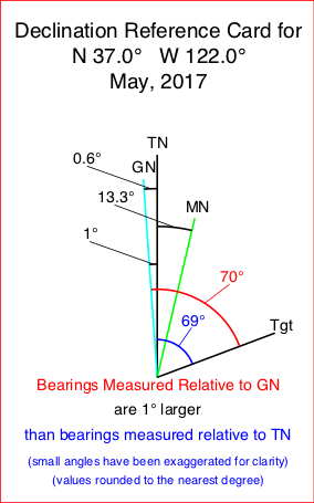
Custom Declination Reference Sheets
June 2017
As a first step in being able to provide customized tools, I am pleased to announce that we are now making customized declination reference sheets. Input you zip code our your latitude and longitude, and you north reference preferences, and we'll make you a reference sheet showing the current magnetic declination, the grid variance, and instructions for compass set up, converting bearings between different north references and plotting bearings onto your map. We are printing these sheets on Rite-In-The-Rain paper, so they will stand up to field use.
Currently, we are including a free declination reference sheet, with every domestic order. We're basing the location for the sheet on the shipping zip code.
If you want a tool for a different location, or for north reference preferences that differ from our default selection, you can design you own declination reference sheet.

Redesigned Website and New Content
November 2013
We hope you like the new look and feel. But more important we hope we have made things easier to find. We have done a lot of work on our product images and descriptions to give you an even better idea of what they can do and how they work. In the process, we fixed a ton of spelling and grammar stuff. But I'm a computer science guy, not an english major, so I'm sure we missed more than a few.
There is a new tutorial on North References for Navigating with a Map, Compass and GPS.
Much of the hard work is under the hood. We've ripped out a lot of crufty html code that caused grief for various browsers. We put in an engine that should allow for lots of future innovation that we already have in the pipeline. Next up we'll be working on the shopping cart. We plan to support a more flexible pricing structure for folks that are buying tools for their entire team.
We are also taking the baby steps towards fully customizable tools. More and more often the best map of the area, is not published by USGS. And more often than not is in a scale that the cartographer chose to fit the area onto the paper, with no need to match the scales of an entire map series.
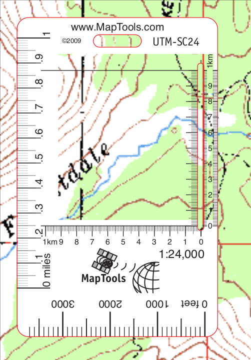
New 1:24,000 Scale Slot Style Tools
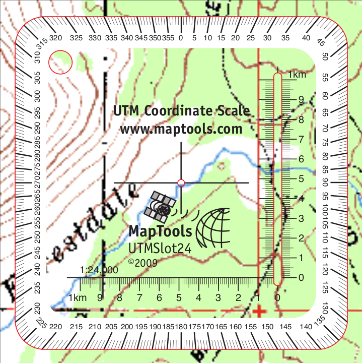
A "pocket sized" and a "credit card sized" tool with a 1:24,000 slot ruler are
new additions to our product line. Both feature a band of opaque white to make reading and finding
the tool easier.
UTMSlot24
UTM-SC24
Improvements to the
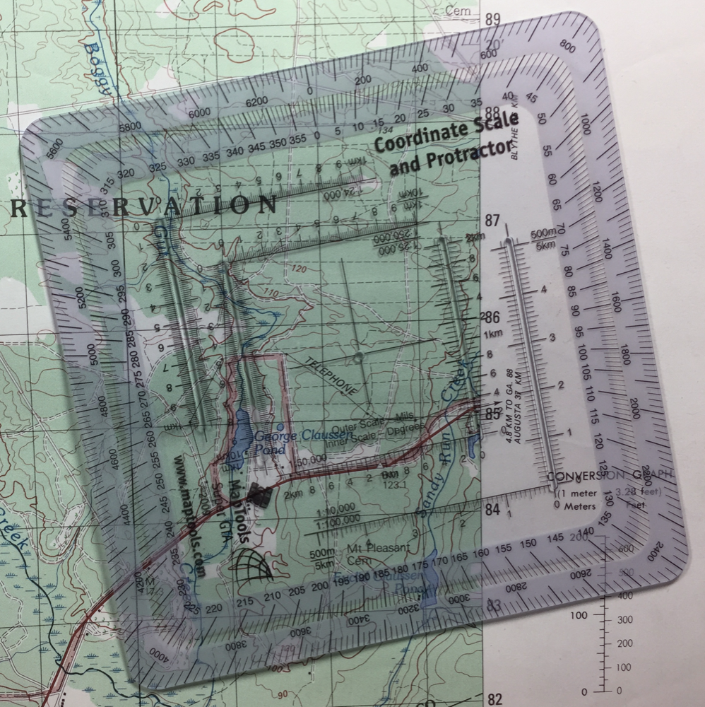
Improved Military Style UTM/MGRS Tool
We have added a band of white ink the two compass roses. This makes reading the compass rose easier
and also keeps the tool from "disappearing" when you place it on the map.
SuperGTA
Improvements to the UTM Grid Overlays for 1:24,000, 1:25,000 and 1:50,000
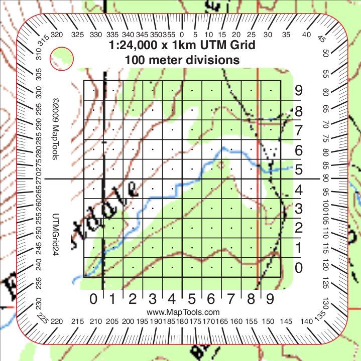
We have added a band of white ink around the edge of the 1:24,000, 1:25,000 and 1:50,000 scale grid
overlays. This makes reading the compass rose and grid numbers easier and also keeps the tool from
"disappearing" when you place it on the map. In the center of each 100m square, on the
1:24,000 and 1:25,000 scale tools, we've added a small dot, which makes it easy to read the
coordinate with a 50m precision. One last thing, we also added a lanyard hole in the upper left
corner.
UTM Grid Overlays
Video Tutorials
Two new Video Tutorials on measuring and plotting latitude longitude coordinates using a MapRuler.