USNG Coordinates
What USNG is
For a hands-on, illustrated walkthrough of reading and writing USNG, the MapTools tutorial USNG Quick Guide covers the same ground as this page in a more visual format.
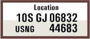
USNG — the U.S. National Grid — is the civilian U.S. packaging of the same underlying UTM grid that the military uses as MGRS. A complete USNG coordinate looks like:
10S GJ 06832 44683
Five parts, identical in structure to MGRS:
10S— Grid Zone Designation. The UTM zone number plus the latitude band letter. Necessary to make the coordinate unique over the entire globe.GJ— 100,000-meter Square ID. Two letters identifying a unique 100km square within the grid zone.06832— Easting. East-west position within the 100km square, in meters. The first two digits come from the western grid line label; the last three are the meters east of that line.44683— Northing. North-south position within the 100km square, in meters. Same logic against the southern grid line.
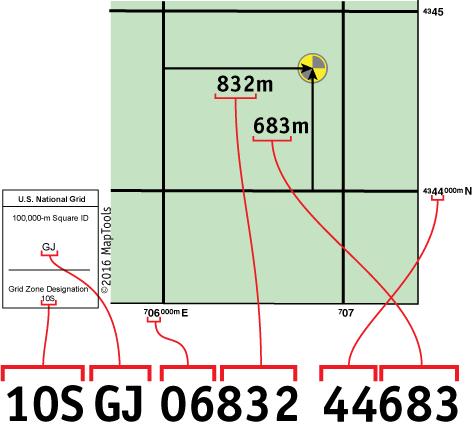
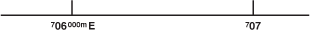
The same map grid lines are used for both USNG and MGRS positions; only the writing convention and the datum handling differ. The grid lines on a 1:24,000-scale USGS quad are 1,000 meters apart, and each is labeled with its UTM easting or northing along the map edge:
Precision through truncation
USNG carries precision in the digit count, the same way MGRS does:
| Form | Precision |
|---|---|
10S GJ 06832 44683 |
1 m |
10S GJ 0683 4468 |
10 m |
10S GJ 068 446 |
100 m |
10S GJ 06 44 |
1 km |
10S GJ 0 4 |
10 km |
When using less precise representation, it is important to truncate rather than round the Easting and Northing values. The Easting and Northing always refer to the southwest corner of the grid square.
USNG specifically recommends at least two digits per axis — so the smallest USNG-permitted area is a 10,000m square (10S GJ 0 4). MGRS allows reference to a full 100km square by letters alone (10S GJ); USNG doesn't.
Differences from MGRS
For students plotting on a topo map, the two systems behave identically. The differences only appear at the edges:
Datum handling under NAD 27
Both systems default to WGS 84 (USNG also explicitly accepts NAD 83 as equivalent). They diverge when applied to the NAD 27 datum, which many older USGS topographic maps still use:
- MGRS shifts the second letter of the 100km square ID by ten letters, with no formal way to specify which datum the coordinate refers to.
- USNG does not shift letters but requires the datum to be specified alongside the coordinate.
Same physical point under NAD 27:
- MGRS (NAD 27):
10S GU 0706832 4344683 - USNG (NAD 27):
10S GJ 0706832 4344683 (NAD 27)
This is a real distinction for users of older USGS maps. See Map Datums for the broader datum story.
Geographic scope
USNG is only defined for use "over all areas of the United States including outlying territories and possessions." That bounded scope is why the standard avoids some of the complications that MGRS has to address — for instance, USNG doesn't need to define the UPS coordinate system for polar regions. A USNG coordinate is always a U.S. coordinate.
Truncation philosophy
MGRS allows reference to an entire 100,000m square (10S EH). USNG suggests a minimum of two digits per axis. Not a hard prohibition — "the USNG does not specifically prohibit 100,000m truncation, but instead omits it from the standard document."
Writing and saying it
USNG is "formally written as an entity without spaces, parentheses, dashes, or decimal points." For human use, do the opposite:
I would encourage you to use spaces when writing USNG coordinate strings, and to pause briefly between logical parts when communicating USNG coordinate strings verbally.
If everyone you're working with is in the same 100km square, USNG (like MGRS) lets you drop the Grid Zone Designator and the 100km square ID and just exchange the easting and northing. Useful within a small operating area; dangerous at the boundaries.
Who uses it
The U.S. National Grid was promoted by the Federal Geographic Data Committee as a clean civilian standard for emergency response, FEMA coordination, search-and-rescue, and inter-agency disaster response. Anyone who reads MGRS can read USNG and vice versa, so the practical question is which one your peers use:
- FEMA-issued maps and disaster-response coordinates are the most common place a civilian sees USNG.
- Some U.S. national parks have begun overprinting USNG grids on their maps.
- Civilian SAR teams trained under FGDC standards use USNG.
Outside those contexts — recreational hiking, private hunting, foreign navigation — you'll more often see UTM, lat/lon, or MGRS.
Common errors
It is easy to make a mistake using truncated position formats. Slipping a digit left or right results in a very different position. Worse, there is no visual clue that an error has been made until the coordinate is plotted.
Same failure mode as MGRS: digit slips are silent. Read the coordinate back. Plot it on the map and confirm the location is plausible before acting on it.
Choosing a coordinate system
For guidance on when to use USNG vs. lat/lon vs. UTM vs. MGRS, see Selecting a Coordinate System.
Further reading on maptools.com
- MGRS vs USNG Differences — how MGRS and USNG diverge on datum handling
- FGDC USNG Standard (PDF) — the federal standards document defining USNG