A Quick Guide to Using MGRS Coordinates
Standing at the center of the marker shown on the map below, a GPS unit set to display position in US National Grid format, would report a location of:

Let's look at where the various parts of the MGRS position come from on the map.
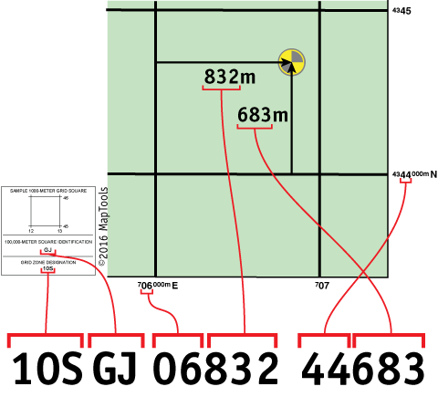
The map has grid lines spaced every kilometer or 1000 meters. The grid is labeled with UTM coordinate values. But the same grid is used for both MGRS and USNG positions. When using MGRS or USNG the small type numbers to the left of the larger type numbers are replaced by the 100,000m Square ID. The vertical grid lines determine East-West position and the horizontal grid lines determine North-South position.
Look along the bottom edge of the map at the labels for the vertical grid lines.
The label,
![]() , reads "seven hundred and six thousand meters East." The label,
, reads "seven hundred and six thousand meters East." The label,
![]() , is an abbreviation for,
, is an abbreviation for,
![]() The two grid lines are 1000 meters apart. The horizontal grid lines are
labeled in a similar manner.
The two grid lines are 1000 meters apart. The horizontal grid lines are
labeled in a similar manner.
The 10S is the Grid Zone Designation you are in. The Grid Zone is necessary to make the coordinates unique over the entire globe.
The GJ is the 100,000 meter Square ID. It identifies a unique 100,000m square within the Grid Zone.
The top set of numbers, 06832, represent a measurement of East-West position, within the 100,000 meter square, in meters. It's called an Easting. Using a map with a 1000m grid, the first two digits are come from the large type on the label for the grid line to the west of the position. The last 3 digits are the distance in meters measured from the western grid line.
The bottom set of numbers, 44683, represent a measurement of North-South position, within the 100,000 meter square, in meters. It's called a Northing. Using a map with a 1000m grid, the first two digits are come from the large type on the label for the grid line to the south of the position. The last 3 digits are the distance in meters measured from the southern grid line.
The MGRS standard states that "To facilitate machine-to-machine communication, an MGRS string is to have no intermediate spaces or punctuation marks and all the letters are to be capitals." I have not strictly followed this part of the standard in these tutorials. The inclusion of spaces to separate the logical parts of the coordinate string has been shown to facilitate the understanding and communication of coordinate strings between humans. I would encourage you to use spaces when writing MGRS coordinate strings, and to pause briefly between logical parts when communicating MGRS coordinate strings verbally.
Truncated position formats for less precise positions
The MGRS format is designed to support measurement precisions of 1m, 10m, 100, 1,000m, and 10,000m. by truncating the grid coordinate values.
| 10S GJ 06832 44683 | - Locates a point within a 1 meter square |
| 10S GJ 0683 4468 | - Locates a point within a 10 meter square |
| 10S GJ 068 446 | - Locates a point within a 100 meter square |
| 10S GJ 06 44 | - Locates a point within a 1,000 meter or 1 kilometer square |
| 10S GJ 0 4 | - Locates a point within a 10,000 meter or 10 kilometer square |
| 10S GJ | - Locates a point within a 100,000 meter or 100 kilometer square |
When all of the coordinates you are working with are localized within the same 100,000 meter square identifier, it is permissible to drop the Grid Zone Designator and the 100,000 meter square id.
| 06832 44683 | - Locates a point within a 1 meter square |
| 0683 4468 | - Locates a point within a 10 meter square |
| 068 446 | - Locates a point within a 100 meter square |
| 06 44 | - Locates a point within a 1,000 meter or 1 kilometer square |
| 0 4 | - Locates a point within a 10,000 meter or 10 kilometer square |
Note: It is easy to make an mistake using truncated position formats. Slipping a digit left or right results in a very different position. Worse, there is no visual clue that an error has been made, until the coordinate is plotted.
Truncate, don't round
When using less precise representation, it is important to truncate rather than round the Easting and Northing values. The Easting and Northing always refer to the southwest corner of the grid square. The size of square represented by a given coordinate will vary with the coordinate's precision. Truncating ensures the more precise squares will always remain within the less precise squares.
Using various tools to plot and measure MGRS positions on a map
Using a GTA style tool to plot/measure a 10m MGRS position
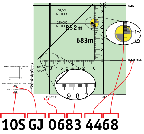
Using a slot style tool to plot/measure a 10m MGRS position
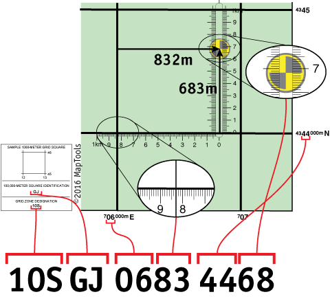
Using a grid style tool to plot/measure a 100m MGRS position
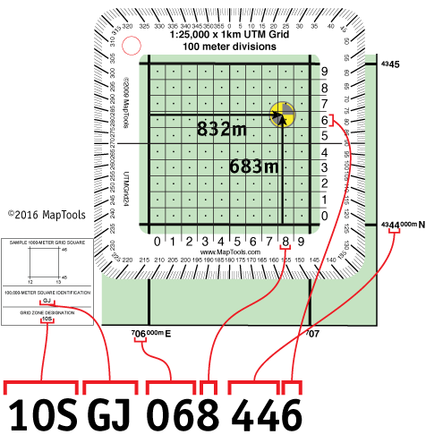
Using a corner ruler roamer style tool to plot/measure a 10m MGRS position
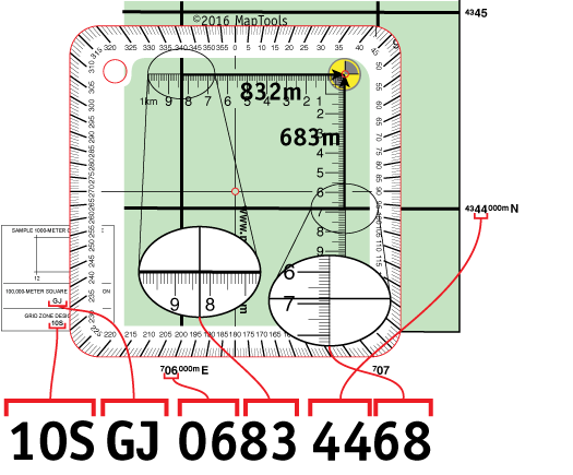
Using a mini corner style tool to plot/measure a 10m MGRS position
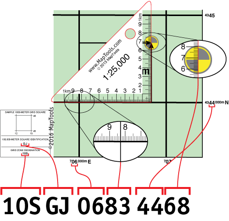
Using a map ruler to plot/measure a MGRS position with 10m precision
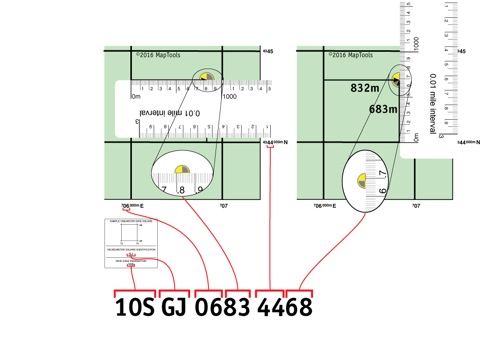
Learn more about...
Map Datums and why they are so important
Locating MGRS grid information on USGS topographic maps
The 100,000 meter square identifier letter pairs
The small differences between USNG and MRGS
Some of the history behind the military adoption of UTM and MGRS