More details about UTM Grid Zones
The world's 60 UTM zones
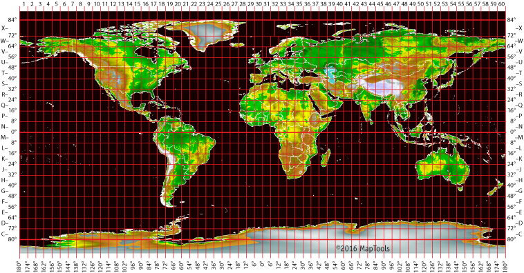
The UTM coordinate system divides the earth into 60 zones each 6 degrees of longitude wide. These zones define the reference point for UTM grid coordinates within the zone. UTM zones extend from a latitude of 80° S to 84° N. In the polar regions the Universal Polar Stereographic (UPS) grid system is used. Note that there are a few exceptions to zone width in Northern Europe to keep small countries in a single zone.
UTM zones are numbered 1 through 60, starting at the international date line, longitude 180°, and proceeding east. Zone 1 extends from 180° W to 174° W and is centered on 177° W.
Each zone is divided into horizontal bands spanning 8 degrees of latitude. These bands are lettered, south to north, beginning at 80° S with the letter C and ending with the letter X at 84° N. The letters I and O are skipped to avoid confusion with the numbers one and zero. The band lettered X spans 12° of latitude.
Eastings and Northings within a zone
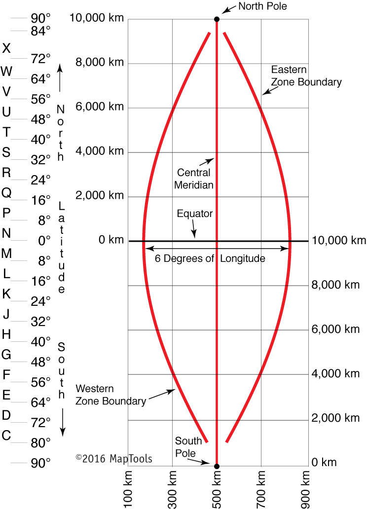
A single grid zone measures about 20,000km tall and only about 700km wide. So the above diagram has been compressed in the vertical axis by about 15X. The eastern and western zone boundaries are truly much straighter.
A square grid is superimposed on each zone. It's aligned so that vertical grid lines are parallel to the center of the zone, called the central meridian.
UTM grid coordinates are expressed as a distance in meters to the east, referred to as the "easting", and a distance in meters to the north, referred to as the "northing".
Eastings
UTM easting coordinates are referenced to the center line of the zone known as the central meridian. The central meridian is assigned an easting value of 500,000 meters East. Since this 500,000m value is arbitrarily assigned, eastings are sometimes referred to as "false eastings"
An easting of zero will never occur, since a 6° wide zone is never more than 674,000 meters wide.
Minimum and maximum easting values are:
160,000 mE and 834,000 mE at the equator
465,000 mE and 515,000 mE at 84° N
(Exceptions to this will be found in the unusual zones in northern Europe.)
Northings
UTM northing coordinates are measured relative to the equator. For locations north of the equator, the equator is assigned the northing value of 0 meters North. To avoid negative numbers, locations south of the equator are made with the equator assigned a value of 10,000,000 meters North.
Some UTM northing values are valid both north and south of the equator. In order to avoid confusion the full coordinate needs to specify if the location is north or south of the equator. Usually this is done by including the letter for the latitude band.
If this is your first exposure to the UTM coordinate system you may find the layout of zones to be confusing. In most land navigation situations the area of interest is much smaller than a zone. The notion of a zone falls away, and we are left with a simple rectangular coordinate system to use with our large scale maps.