UTM Zones
UTM divides the Earth's surface into a tiled grid of zones. Each zone is a flat, locally-rectangular projection of one slice of the curved Earth. The local easting and northing measured off a topo map are unique only inside one zone — the Grid Zone Designation at the front of a UTM coordinate (10S, 13T, 33N) is what makes the full coordinate globally unique.
UTM Zones and Bands
There are 60 UTM zones, each spanning 6° of longitude.
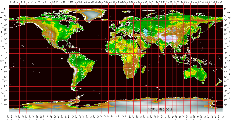
UTM zones are numbered 1 through 60, starting at the international date line, longitude 180°, and proceeding east.
Zone 1 occupies 180°W to 174°W, centered on its central meridian at 177°W. Zone 60 wraps back around to the date line. Coverage extends from 80°S to 84°N — most of the inhabited Earth — with a handful of exceptions in northern Europe where zone boundaries are bent to keep small countries in a single zone.
Within a zone, latitude is divided into 8°-tall horizontal bands labeled with letters from C (south) to X (north). The system skips letters I and O to avoid confusion with the numbers 1 and 0. Band X is the exception — it's 12° tall to extend coverage all the way to 84°N.
A Grid Zone Designation is the zone number plus the band letter: 10S, 13T, 33N. The full Grid Zone Designation makes a UTM coordinate unique anywhere on Earth.
Anatomy of a UTM Zone
A single zone is a tall, narrow rectangle of about 20,000 km tall by 700 km wide at its widest. Inside the zone the UTM grid is a flat, square Cartesian system measured in meters.
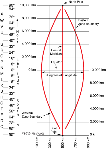
Two reference values define the grid:
- Central meridian and false easting. The zone's central meridian is assigned an easting value of
500000 mE— exactly halfway across the conventional easting range. This arbitrary assignment is why eastings are sometimes called "false eastings": an easting of zero never occurs anywhere in the zone, because the convention pushes the origin off to the side. A 6°-wide zone never gets wider than about 674 km, so valid eastings fall in roughly the range:- At the equator:
160000 mEto834000 mE. - At 84°N:
465000 mEto515000 mE— the zone narrows substantially toward the poles.
- At the equator:
- Equator and false northing. For locations in the northern hemisphere, the equator is assigned a northing of
0 mNand northings increase to the north. For southern hemisphere locations, the equator is assigned10000000 mN(ten million meters north) and northings decrease to the south to avoid negative numbers.
That second convention has a consequence: a northing alone is ambiguous between hemispheres. The latitude band letter resolves the ambiguity (bands C–M are south of the equator, N–X are north).
What Happens at a Zone Boundary
Zone boundaries are the seams where the flat-projection approximation has to break. Two practical consequences for the navigator:
- Coordinates across a boundary aren't directly comparable. A position 1 km east of the zone boundary has a different easting than a position 1 km west — the easting "resets" at the boundary because each zone has its own central meridian and false-easting origin. Subtracting the two eastings gives you a meaningless number.
- The map will tell you, but you have to look. USGS topo maps near zone boundaries show grid markings for both adjacent zones along the appropriate edge. Students who don't notice the second set of grid labels can produce coordinates that are off by enormous amounts.
On a USGS topo map, the UTM grid appears in one of two forms — either printed black grid lines spaced every 1000 m and labeled along the edge:
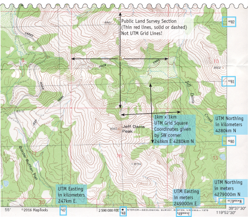
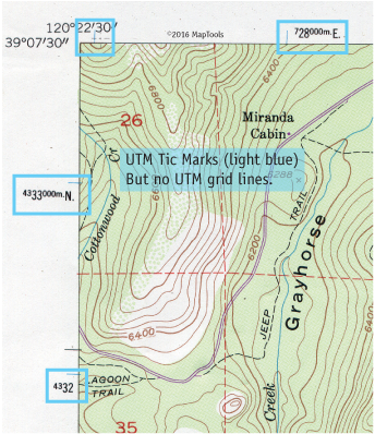
…or, on older 1:24,000 quads, just blue tick marks along the neat line that the user is expected to connect with a straightedge:
UTM grid lines are not exactly North-South or East-West anywhere but in the center of a zone.
This is the convergence angle — the small twist of the UTM grid relative to True North and longitude lines, which grows toward the edges of a zone. See North References (True, Magnetic, Grid) and Declination for the full three-norths picture.
For most recreational navigation in the middle of a zone, the convergence is small enough to ignore. Near a zone boundary, or at high latitudes where zones narrow significantly, it becomes meaningful.
What about the polar regions?
UTM doesn't cover the poles. Beyond 84°N and 80°S, the zones get too narrow to be useful and the projection breaks down. Polar coverage uses a separate system: the Universal Polar Stereographic (UPS) grid, which projects each polar cap onto a flat plane centered on the pole.
For most users this is a footnote — UPS comes up only for polar expeditions, scientific work in Antarctica, and the occasional aviation chart. The U.S. National Grid avoids UPS entirely by limiting itself to U.S. territory.
Further reading on maptools.com
- Grid Zone Details — the UTM zone grid and what each piece means