USGS Topographic Maps
The standard U.S. topographic map
The U.S. Geological Survey publishes the standard topographic coverage of the country, and for decades that has been the map most American land navigators learn on. Each sheet covers a quadrangle — a rectangle bounded by lines of latitude and longitude — which is why the sheets are called "quads." The workhorse is the 7.5-minute quad printed at 1:24,000: one sheet spans 7.5 minutes of latitude and 7.5 minutes of longitude, and at that scale it's detailed enough to show individual creeks, switchbacks, buildings, and contour lines. This is the deep dive on the USGS series specifically; for the broader survey of map kinds, see Map Types.
What makes a USGS quad worth knowing is that it carries everything you need to use it with a compass and a GPS, printed right on the sheet. You just have to know where to look in the margin.
The map collar
The blank border around a USGS quad — the collar or margin — is not decoration. It holds the reference information that turns the printed picture into a tool you can navigate with:
- Quad name and adjoining sheets. The name is printed in the corners, and the names of the eight neighboring quads are noted around the edges so you can find the next sheet over.
- Scale and bar scales. The ratio (1:24,000 on a standard 7.5' quad) plus printed bar scales in feet, miles, and meters. The bar scale is the one to trust if the sheet has been photocopied or resized — see Map Scale.
- Contour interval. The constant vertical distance between contour lines, stated near the scale. See Map Reading for reading contours.
- Declination diagram. The angle between true north, magnetic north, and grid north for the sheet's location and date. See Map Reading.
- Datum. The earth model the coordinates are based on — modern quads use NAD 83, but many older sheets use NAD 27. This is the one to check before you match the map to your GPS; see Map Datums.
- Index map and revision history. A small locator map and the survey/revision dates. Maps go stale, so the date matters.
Collar details from a sample 7.5' quad (Sharktooth Peak, CA):
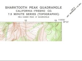 *Quad name and series info, printed in the map's corner.*
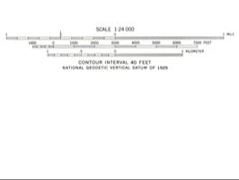 *Bar scale in feet, miles, and meters, with the contour interval printed just below it.*
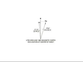 *Declination diagram — true north, magnetic north, and grid north for this sheet and date.*
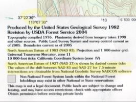 *Datum statement and UTM zone, showing both the current NAD 83 value and the superseded NAD 27 value for the same corner.*
 *Index map locating the quad within the state.*
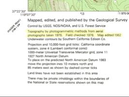 *Revision history and survey control notes.*
Coordinate grids on the quad
USGS large-scale maps are friendly to whatever coordinate system you prefer, but they don't all print the grid the same way.
- UTM. Some quads print the full 1km UTM grid as thin black lines. Many others print only short blue tic marks along the edges marking where the grid lines would fall — you connect them yourself with a straightedge. Tic labels are sometimes the full coordinate in meters and sometimes abbreviated (the right-most three digits dropped on a 1,000m grid), with the full value spelled out in two or more corners.
- Lat/lon. The neat lines of Latitude and Longitude are usually not drawn across the face either. Instead, ticks sit on the edges and small crosses sit in the interior at 2.5-minute spacing; you draw the lines by connecting an edge tick to the matching interior cross.
 *UTM grid tic mark with an abbreviated coordinate label.*
 *Interior lat/lon cross mark at 2.5-minute spacing.*
Don't confuse either of these with the Public Land Survey System section lines you'll see in the western states — those nominally one-square-mile sections are oriented to true north and numbered 1 to 36, and inexperienced users sometimes mistake them for the UTM grid. See Public Land Survey System (PLSS).
Series and scales
The 7.5-minute 1:24,000 quad is the one most people mean by "a USGS topo," but it isn't the only series. Older and broader coverage exists at 1:62,500 (the 15-minute series, which typically carries 1km UTM tics) and 1:100,000, each trading detail for the amount of ground on one sheet. When you pick a sheet, you're trading detail against coverage — the larger-scale 1:24,000 shows the most ground detail over the smallest area.
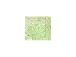
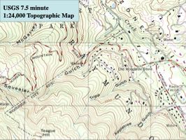 *USGS 7.5 minute, 1:24,000 topographic map.*
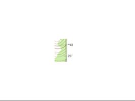
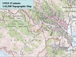 *USGS 15 minute, 1:62,500 topographic map.*
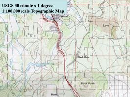 *USGS 30 minute x 1 degree, 1:100,000 topographic map.*
Where to get them
The paper 7.5-minute quad described above is now largely a historical artifact. USGS discontinued the traditional topographic mapping program, and print distributors have mostly exited — for most areas, tracking down an actual old-style paper quad is hard. The realistic modern picture is different enough that it's worth walking through separately.
The current USGS product: US Topo
The USGS map store (store.usgs.gov) still sells current-coverage topographic sheets — as of June 2026, around $15 per printed sheet, or free as a PDF download. But the US Topo product is a different kind of map than the classic quad: instead of contours and cartographic symbols on a bare white base, the data is overlaid on an orthorectified aerial photograph. If you're used to the traditional look, it reads as strange — the same information is there, but the visual language is completely different.
 *SE corner of a sample US Topo PDF — contour lines and grid overlaid on an orthorectified aerial photo, instead of the traditional bare cartographic base.*
The PDF's page size is 24" × 29" — larger than any standard home or small-office printer handles in one piece, so printing it yourself at native size means a large-format printer or a print shop.
Practical paper-map sources today
For most people who actually want a printed paper topo in hand, USGS's own distribution isn't the practical path anymore. CalTopo (caltopo.com) has effectively become the default: you pick your own area and your own scale — nothing forces 1:24,000 — and print or order a sheet with the classic-style cartographic rendering. MyTopo (mytopo.com) is a similar commercial print-on-demand option in the same space. Either is a more realistic recommendation than "go buy a USGS quad."
The USGS National Map Viewer (apps.nationalmap.gov) is the official live source if you want to pull current USGS data yourself or generate a custom US Topo PDF for an arbitrary area. Worth knowing it exists, but it's not the easiest way to get a map with traditional-style coordinate grids and collar labeling — the viewer is built for GIS-style data access first, readable field-map output second.
Whichever route you take, check the collar (or its equivalent) of the final sheet for its scale, datum, and grids before you rely on it in the field.