Map Projections
What a map projection is
A map projection is the method used to take the curved surface of the Earth and lay it out flat on a sheet of paper or a screen. The catch is geometry: you cannot peel a globe and press it flat without stretching, tearing, or squashing some part of it. Every flat map is therefore distorted somewhere — there is no perfect one. The projection is just the systematic set of rules for how a particular map trades one kind of distortion for another.
For day-to-day navigation you almost never have to choose a projection or do anything with it directly. What matters is knowing it's there, because it's the reason the lat/lon grid and the UTM grid don't line up as simple squares, and the reason grid systems and UTM zones exist in the first place.
Why flat maps are always distorted
The Latitude and Longitude grid of parallels and meridians draws cleanly on a globe. But the globe's surface can't be flattened without distortion, so a perfect flat map is impossible. This is the "orange peel" problem: try to lay a peeled globe flat and you either tear it or squash it.
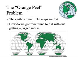 *The "orange peel" problem: the earth is round, maps are flat, and there's no way to go from one to the other without something giving.*
The usual trick is to wrap the globe in a simple shape you can unroll flat — a cylinder, a cone, or a plane laid against it — project the grid onto that shape, then cut it open and lay it out.
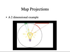 *The projection mechanism in miniature: a light source inside the globe casts the grid outward onto a flat surface.*
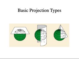 *The three basic projection surfaces: planar, conic, and cylindrical, each wrapped against the globe.*
Different wrapping shapes and different projection rules preserve different things: some keep shapes correct in any small area, some keep areas in true proportion, some keep directions true. No single projection does all of them at once, which is why so many exist — each is good for some jobs and poor for others.
The classic illustration is the Mercator projection, where the meridians become evenly spaced vertical lines. It's excellent for charting a steady compass course as a straight line, which is why it became standard for marine and air navigation. But it badly exaggerates size toward the poles — on a Mercator map Greenland looks larger than South America, even though South America is many times bigger.
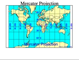 *The Mercator projection — straight vertical meridians make it excellent for plotting a steady compass course, at the cost of exaggerating size near the poles.*
The same ground looks different depending which projection drew it. Below, three projections of the same area of the United States — Mercator, Lambert Conformal Conic, and un-projected latitude/longitude — are overlaid on each other; where the lines diverge is the distortion.
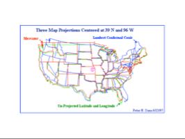 *Three projections of the same area — Mercator, Lambert Conformal Conic, and un-projected lat/lon — overlaid. Where the lines diverge is the distortion.*
The projection a land navigator actually meets
The one that underlies most modern land-navigation maps is the Transverse Mercator. It's the Mercator idea turned on its side: instead of wrapping the cylinder around the equator, it's turned to touch the globe along a chosen meridian (a north-south line). That keeps scale and angles very accurate in a narrow north-south strip on either side of that meridian — exactly the right tradeoff for a continent's worth of mapping done in tall, skinny slices.
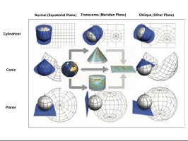 *Normal, transverse, and oblique aspects, for each of the three projection surfaces. Transverse Mercator is the cylindrical case turned on its side — the middle column, top row.*
This is the foundation of the UTM grid: the Earth is divided into UTM Zones six degrees of longitude wide, and each zone gets its own Transverse Mercator projection centered on its own meridian. Slicing it into zones keeps the distortion within any one zone small enough that you can treat the UTM grid as a flat, square, meters-based grid and measure distances and bearings on it directly. That's the whole payoff: a grid you can do simple flat-paper math on, made possible by a projection chosen to keep error tiny within each zone.
A projection is a different thing from a datum and from Map Scale: the projection is how the round Earth gets flattened, the datum is which Earth-model the coordinates are measured against, and the scale is how much the map is shrunk. A complete map specifies all three — you'll find the projection named in the fine print of the map's margin alongside the datum.
Other projection families you may see named
Transverse Mercator isn't the only projection you'll run across by name. Two others show up often enough to recognize on sight, even without going deep on the math:
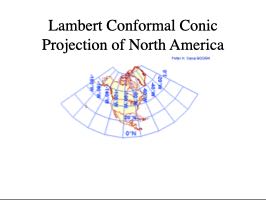 *Lambert Conformal Conic projection of North America — a conic projection, common on aeronautical sectional charts.*
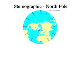 *Stereographic projection centered on the North Pole — a planar projection, useful for polar regions where cylindrical projections like Mercator break down.*