Orienting Your Map
What is orienting your map
Orienting your map means turning it so its north points the same direction north points on the ground — so that north on the paper lines up with north in the world, east with east, and so on. Once the map is oriented, everything on it sits in the direction it really lies: the ridge drawn to the upper-left of your position is the ridge you'll actually see off to your upper-left.
This is the first thing you do before you read a map in the field. An unoriented map is a puzzle — you have to mentally rotate it every time you ask "which way is that?" An oriented map answers directly. Orient the map before you try to locate yourself on it, before you pick a route, and before you take any bearing off it.
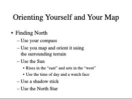
There are two ways to orient: by matching what you see (terrain association) and by compass.
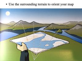
Orienting by terrain association
If you can see the country around you and recognize features on the map, you don't need anything but your eyes. Lay the map flat and rotate it until the pattern of roads, rivers, ridgelines, and other features on the paper lines up with the same features on the ground. As you turn the map, the shapes will suddenly "click" into place — the bend in the stream on the map points the same way as the bend you can see, the line of hills runs the same direction. When the patterns match in every direction you look, the map is oriented.
This works best from a spot with a good view — a hilltop or open vantage where several recognizable features are visible. It's fast, needs no tools, and is the everyday method for following a map as you travel. It only fails when you can't see far enough or can't tie what you see to what's drawn — in fog, dense timber, or featureless terrain. That's when you reach for the compass. See Map Reading for recognizing features in the first place.
Orienting by compass
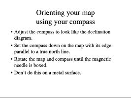
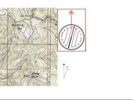
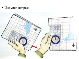
When you can't match terrain, use a compass to find north directly, then rotate the map to agree with it. The catch is that a compass points to magnetic north while the map is drawn to true or grid north, so the two don't line up by default — you have to account for the difference (declination). This is exactly the three-norths problem covered in North References (True, Magnetic, Grid) and Declination: set your compass for the local declination, or offset the map by that angle, so the compass needle and the map's north reference point the same way. Then turn the map until they agree, and it's oriented. See Compass Uses for the mechanics of the compass itself.
Orienting yourself
Orienting the map is half the job; the other half is knowing where on it you're standing. With the map oriented, look around and find features you can identify on both the ground and the paper. Often that's enough — if you're at the trail junction or the lake outlet that's drawn right there, you've placed yourself.
When your spot isn't that obvious, there's a small catalog of techniques for fixing your position on the map, from sighting on a couple of distant landmarks to reading a GPS. Those belong on their own page; see Locating Yourself on the Map. The point for now: orienting the map comes first, because every method of finding yourself depends on the map already agreeing with the ground.
Slides from John's Wilderness Navigation class
Slides from John Carnes's 4.5-day Wilderness Navigation class (Friday evening + Saturday + Sunday × two weekends) that illuminate this concept. Useful as diagram references for your own presentations and for exercise handouts. The slides need a speaker — they're diagram-heavy, light on prose. The decks are split by class weekend: D1 is the first weekend's deck, D2 the second's.
Orienting your Map
2 slides — D1 #441-442
- Keynote: map-orientation.key
- PowerPoint: map-orientation.pptx
- Full-resolution diagrams (drop into your own deck)
Slides (2):
Orienting your Map — D2 opener
3 slides — D2 #46-48
These three slides are logically part of the map-orientation topic (per topic_map.yaml) but are still physically bundled inside John's "Orienting Yourself and Your Map" Keynote deck (D2 #46-62) — the next scripts/06_split_key_files.py run will move them into the map-orientation/ deck folder alongside D1 #441-442. The rest of that bundled deck now belongs to Locating Yourself on the Map and Alternate North-Finding Methods.
- Keynote: orienting-yourself-and-your-map.key
- PowerPoint: orienting-yourself-and-your-map.pptx
- Full-resolution diagrams (drop into your own deck)
Slides (3):
Attribution: Slide from John Carnes's "Wilderness Navigation" class, MapTools.