Locating Coordinate Grid Information on USGS Maps
Note: Product edges and interior cutouts are shown with a thin red line.
Neither the red lines, colored background, nor map image are printed on the actual tool.
(more info)
Product Description
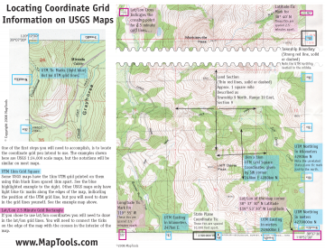
This is a handout I use in my navigation classes. This is a full color page with a sample map showing where to find coordinate grid information for UTM and Latitude/Longitude on USGS topographic maps. Public land survey sections and State Plane coordinates are also shown. You can download the pdf for free. We'll send you a copy with your order for free. Or, if you need a bunch for your class, we sell them for less than you could print them on your own printer.
Add to Shopping Cart
| Item description | Quantity | Price | Quantity |
Specifications
Dimensions:Height: 4.250 in. (108mm)
Width: 5.500 in. (140mm)
Thickness: 0.010 in. (0mm)
Made in United States.
