Using a UTM Corner Ruler
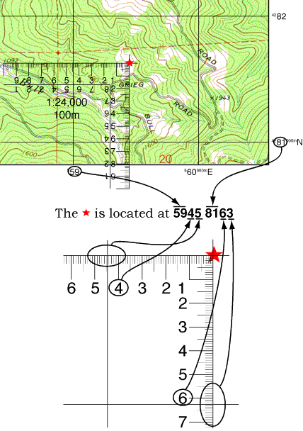
A UTM Corner Ruler consists of two scales at right angles to each other. UTM Corner Rulers will typically provide an additional digit of precision beyond a UTM Grid Overlay. On a 1:24,000 scale map you will be able to determine a position to within a 10m square. The trade off is that the Corner Ruler is somewhat harder to use.
Start by placing the top right corner of the Corner Ruler on the SW corner of the UTM grid that contains the feature. The ruler edges should extend to the West and South. To find the UTM coordinates of a feature marked on your map slide the rulers North and East until the corner is on top of the feature to be measured. Read the UTM coordinate values from the starting grid lines. To locate a UTM coordinate on the map slide the ruler North and East until the desired distances are indicated at the grid lines.
If the grid square you are using is on the edge of your map, you may need to start from a corner other than the southwestern one. You can still use the corner ruler, remember that UTM coordinate values increase from West to East and from South to North.
You should return to the exercise and try it using a 1:24,000 scale UTM Corner Ruler.
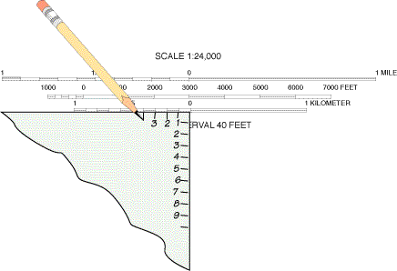
If you are using an odd scaled map or if you left your UTM tools behind, you can quickly make a simple corner ruler using the scale bars on the map.
Start with the corner of a scrap of paper. Mark off a one kilometer distance and the 100m subdivisions using the metric scale bar. Repeat this process along the other edge. Number both rules starting from the corner which would be zero.
Overlays containing UTM corner rulers for several different map scales are available from MapTools.
The corner ruler is the harder tool to picture from a still image, so it may help to watch one
work. The interactive UTM tutorial demonstrates the slot
style tool, which carries the same pair of scales at right angles reading zero at the corner, and
it places the tool honestly — landing on the grid line at the wrong spot first, checking that
the scale really does span the full kilometer, and only then sliding into position:
Measure a feature's coordinate
Locate a coordinate on the map
