UTM Slot Tool (14 Scales)
14 Scales in a compact tool


Product Description
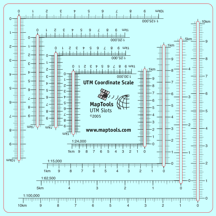
This tool combines 14 of the most common topographic map scales into a single tool about the size of a CD. The slot style tool gives easy access to the map for marking, while maintaining superior accuracy.
Add to Shopping Cart
Specifications
Scales:- 1:15,000 x 1km
- 1:10,000 x 1km†
- 1:20,000 x 1km
- 1:24,000 x 1km
- 1:25,000 x 1km
- 1:30,000 x 1km
- 1:62,500 x 5km
- 1:100,000 x 10km
- 1:125,000 x 10km
- 1:150,000 x 10km†
- 1:200,000 x 10km†
- 1:250,000 x 10km†
- 1:300,000 x 10km†
- 1:1,000,000 x 100km†
For example, a 1:100,000 x 10km tool can be used as a 1:10,000 x 1km tool by dividing the scale and grid distance by 10, and as a 1:1,000,000 x 100km tool by multiplying the scale and grid distance by 10.
Tool Dimensions:
Height: 8.500 in. (216mm)
Width: 6.000 in. (152mm)
Thickness: 0.030 in. (1mm)
Weight: 1.000 oz. (28g)
Package Dimensions:
Height: 8.500 in. (216mm)
Width: 5.500 in. (140mm)
Thickness: 0.030 in. (1mm)
Made in US.
Related Products
| Item description | Price |
|
Locating Coordinate Grid Information on USGS Maps Part Id: GridsSheet, Made in US, UPC: 824249000986 |
$6.95 |
|
UTM Slot -- Large Classroom Training Aid Part Id: UTMSlot-TA, Made in US, UPC: 824249002539 |
$22.95 |
How to use products like this...
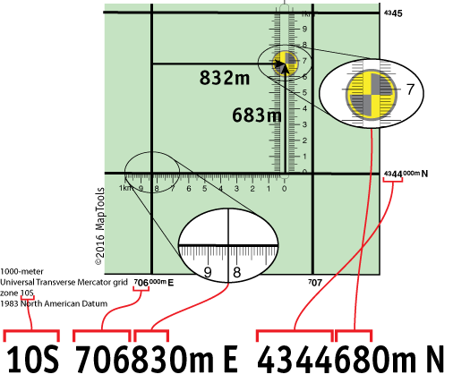
Using a slot style tool to plot/measure a 10m MGRS position
Here is a tutorial on using this type of tool.
Here is information on using the Universal Transverse Mercator coordinates (UTM).
Here is information on using the United States National Grid (USNG).
Here is information on using the Military Grid Reference System (MGRS).